Hurricane season forecast is 'below normal' -- but it comes with a warning
Published in Weather News
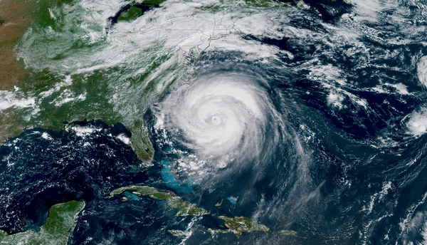
The 2026 Atlantic hurricane season is expected to be “below normal,” largely due to an El Niño weather pattern, according to the National Oceanic and Atmospheric Administration.
NOAA’s hurricane season outlook, released Thursday, forecasts 8 to 14 named storms, including three to six hurricanes and one to three major hurricanes.
Forecasters say there’s a 55% chance of a below-normal season, a 35% chance of a near-normal season, and a 10% chance of an above-normal season. An average season has 14 named storms with seven hurricanes, including three major hurricanes, according to NOAA.
Hurricane season begins June 1 and ends Nov. 30.
Despite the outlook, NOAA administrator Neil Jacobs cautioned people not to let their guard down.
“Even though we’re expecting a below-average season in the Atlantic, it’s very important to understand that it only takes one,” Jacobs said during a news briefing Thursday. He noted that Category 5 hurricanes have made landfall during below-average seasons in the past.
NOAA’s forecast closely aligns with several other leading commercial and academic projections. Last month, forecasters at Colorado State University predicted 13 named storms, including six hurricanes and two major hurricanes with sustained winds of at least 111 mph. In March, AccuWeather predicted between 11 and 16 named storms for the 2026 season.
Forecasters have pointed to El Niño — a recurring climate pattern marked by warmer-than-normal ocean temperatures — as a key reason for the expected slowdown in storm activity.
One of El Niño’s biggest effects on the Atlantic basin is typically a reduction in hurricanes and tropical storms. Hurricanes develop through strong upward motion in the atmosphere, but El Niño increases upper-level wind shear, which can disrupt storm formation and make it more difficult for storms to strengthen.
There’s a 98% chance of El Niño conditions occurring this season, and an 80% chance that El Niño will be moderate to strong in the Atlantic, Jacobs said on Thursday.
Last year’s most destructive storm was Hurricane Melissa, which made landfall in Jamaica as a Category 5 hurricane. The storm caused nearly $9 billion in damage and was blamed for 95 deaths across the Caribbean.
‘Everyone has to be ready’
The best time to start preparing for hurricane season is now, National Weather Service Director Ken Graham said Thursday. He urged people to stock up on nonperishable food and medicine and be prepared to possibly go without electricity for weeks. Radios and flashlights, he said, are essential. Those with pets should also include them in their preparation plans.
Graham emphasized that people shouldn’t let the words “below-average” affect how they prepare, and not to underestimate how quickly major storms can develop and move across the Atlantic.
If you think “you’re going to have weeks’ notice, plenty of time,” he said, “that is not the case.”
One statistic that stands out to Graham when reviewing storm records is that every Category 5 hurricane to make landfall in the U.S. was “tropical storm or less three days out ... they get here quick.”
People should also prepare for all the potential impacts of a storm, including tornadoes, heavy rain, damaging winds, high surf, rip currents and storm surge, Graham said.
Over the last 10 years, more than half of the deaths have been from flooding, with many of those being inland and in vehicles, he said.
He encouraged people to review their evacuation plans and warned about the dangers of floodwaters.
“I don’t think the public fully realized that six inches of fast-moving water will knock you off your feet,” Graham said. “Twelve inches will carry most cars away.”
“Check on your neighbors, check on your family, make sure to have that preparedness,” Graham said.
New and old tech
NOAA will be rolling out new technology this year including the use of artificial intelligence through AI-based versions of various forecast systems, including a model developed in partnership with Google DeepMind, Jacobs announced on Thursday.
But the old tech is still around, including two P-3 aircrafts dubbed as “Kermit” and “Miss Piggy”, which are marking 50 years of service.
“Despite their age, they are equipped with state-of-the art technology inside and out,” NOAA Rear Admiral Chad Cary said.
There’s also the hurricane hunter known as the Gulfstream IV. Flying at about 45,000 feet, the plane circles and surveys hurricanes from above, collecting data on weather patterns such as steering currents that influence the storm below. The P-3s operate at much lower altitudes, around 10,000 feet, flying directly through a hurricane’s eyewall.
“The aircraft carry a suite of specialized instrumentation used to help us better understand and forecast hurricane intensity, structure and the hazards that impact the communities in the path of these storms,” Cary said.
NOAA is also expanding advanced flood and hurricane forecasting through high-resolution mapping services that will allow people to see the streets and neighborhoods likely to go underwater. The mapping covers 60% of the U.S. population and will expand to nearly 100% by late September 2026.
NOAA also launched an experimental rain rate dashboard, a customizable, real-time tool that shows the probability of extreme rainfall a week in advance for more than 60 U.S. cities.
©2026 Miami Herald. Visit at miamiherald.com. Distributed by Tribune Content Agency, LLC.


Comments